资源介绍
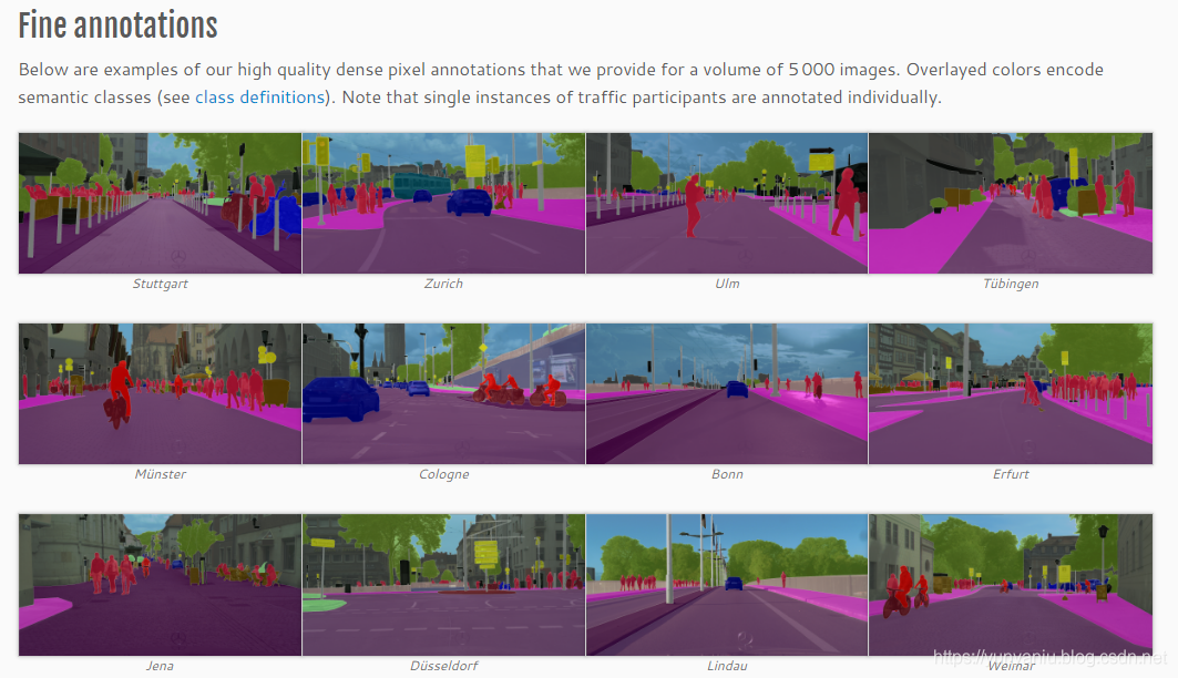
Cityscapes has 5000 images of driving scenes in urban environments (2975 train, 500 Val, 1525 test). It has 19 categories of dense pixel labeling (97% coverage), of which 8 have instance level segmentation. Cityscapes data set, namely urban landscape data set, is a new large-scale data set, which contains a set of different stereo video sequences, recording street scenes in 50 different cities.
Urban landscape data focus on the semantic understanding of urban street scenes. The large data set contains a variety of stereo video sequences recorded in street scenes from 50 different cities. In addition to 20000 weak annotation frames, it also contains 5000 high-quality pixel level annotations. As a result, the data set is of a much larger order of magnitude than previous datasets. The cityscapes dataset has two sets of evaluation standards: fine and coat. The former provides 5000 fine labeled images, while the latter provides 5000 fine labeled images plus 20000 coarse labeled images.
The cityscapes dataset contains 2975 images. It contains street view pictures and corresponding labels. The size is 113mb. Cityscapes data set, jointly provided by three German units including Daimler, contains stereo vision data from more than 50 cities.
1. Characteristics of cityscapes dataset
Pixel level annotation;
Provide algorithm evaluation interface.
2. The purpose of cityscapes dataset
evaluate the performance of visual algorithm in the main tasks of urban scene semantic understanding: pixel level, instance level, floodlight semantic annotation;
Support research aimed at utilizing large (weak) annotated data, such as for training deep neural networks.
3. Sample explanation
The first image is an example of a high-quality dense pixel annotation of, providing 5000 images. Overlapping color coding semantic classes (see class definition). Note that individual instances of traffic participants are individually labeled. The second is rough annotation. In addition to fine annotation, we also worked with Pallas ludens to provide thicker polygon annotations for a set of 20000 images. Similarly, overlapping colors encode semantic classes (see class definition). Note that our goal is not to annotate a single instance, but we mark polygons that cover a single object.


4、Features
Type of annotations
- Semantic
- Instance-wise
- Dense pixel annotations
Complexity
- 30 classes
- See Class Definitions for a list of all classes and have a look at the applied labeling policy.
Diversity
- 50 cities
- Several months (spring, summer, fall)
- Daytime
- Good/medium weather conditions
- Manually selected frames
- Large number of dynamic objects
- Varying scene layout
- Varying background
Volume
- 5 000 annotated images with fine annotations (examples)
- 20 000 annotated images with coarse annotations (examples)
metadata
- Preceding and trailing video frames. Each annotated image is the 20th image from a 30 frame video snippets (1.8s)
- Corresponding right stereo views
- GPS coordinates
- Ego-motion data from vehicle odometry
- Outside temperature from vehicle sensor
Benchmark suite and evaluation server
- Pixel-level semantic labeling
- Instance-level semantic labeling
5. Labeling Policy
Marked foreground objects cannot have holes, that is, if some background is visible "through" some foreground objects, it is considered to be part of the foreground. This also applies to areas where two or more classes are highly mixed: they are marked with foreground classes. For example: the leaves or sky in front of the house (all trees), transparent windows (all cars).
6、Class Definitions
Please click on the individual classes for details on their definitions.
| Group | Classes |
|---|---|
| flat | road · sidewalk · parking+ · rail track+ |
| human | person* · rider* |
| vehicle | car* · truck* · bus* · on rails* · motorcycle* · bicycle* · caravan*+ · trailer*+ |
| construction | building · wall · fence · guard rail+ · bridge+ · tunnel+ |
| object | pole · pole group+ · traffic sign · traffic light |
| nature | vegetation · terrain |
| sky | sky |
| void | ground+ · dynamic+ · static+ |


